Home >> About Riverview West >> Crime, Safety, & Community >> Safety & Disaster Preparedness >> Tsunami Preparedness
Tsunami Preparedness
Riverview West Neighborhood Lies within the California Tsunami Inundation Zone
. Feb. 2, 2019
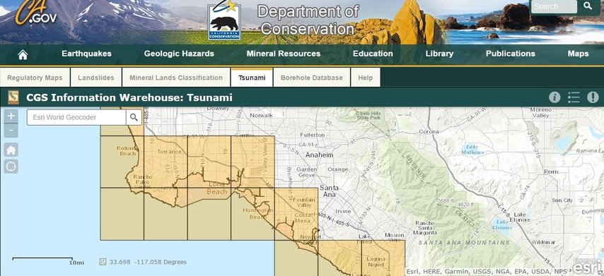
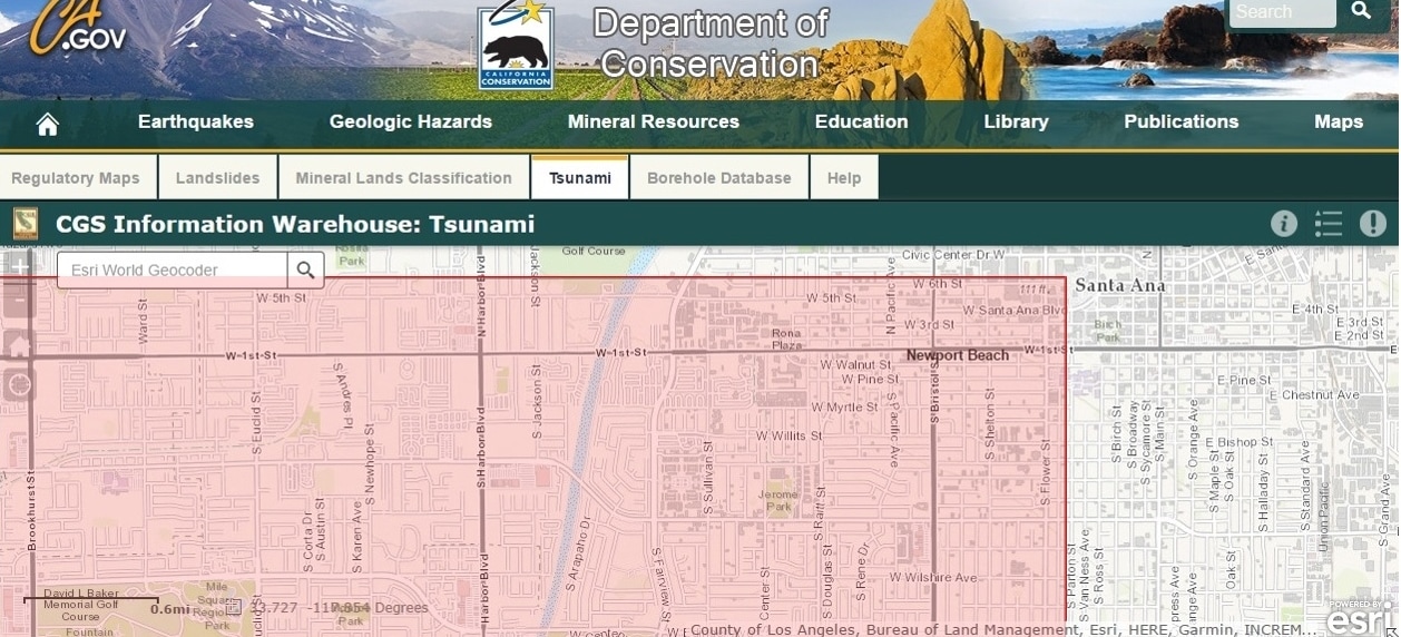
According to the State of California's Department of Conservation's Tsunami Inundation Map, Santa Ana's Riverview West Neighborhood lies within the tsunami inundation zone.
According to this interactive map, the tsunami inundation zone for the City of Santa Ana extends as far north as just north of 6th St. and as far east as just east of Flower St. in the City of Santa Ana. The coastline nearest Riverview West lies to both the south and the west, so water could rush in from both directions, cover the City of Fountain Valley, and cover nearly 3/4 of Riverview West Neighborhood.
However, there are numerous tsunami inundation maps for Orange County circulating the internet; some maps make a projection based on technological models of the largest known tsunamis, and some maps make less alarming projections. This is just one tsunami inundation map posted on the State of California's Department of Conservation's website.
. Feb. 2, 2019
According to the State of California's Department of Conservation's Tsunami Inundation Map, Santa Ana's Riverview West Neighborhood lies within the tsunami inundation zone.
According to this interactive map, the tsunami inundation zone for the City of Santa Ana extends as far north as just north of 6th St. and as far east as just east of Flower St. in the City of Santa Ana. The coastline nearest Riverview West lies to both the south and the west, so water could rush in from both directions, cover the City of Fountain Valley, and cover nearly 3/4 of Riverview West Neighborhood.
However, there are numerous tsunami inundation maps for Orange County circulating the internet; some maps make a projection based on technological models of the largest known tsunamis, and some maps make less alarming projections. This is just one tsunami inundation map posted on the State of California's Department of Conservation's website.
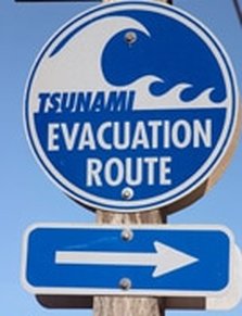
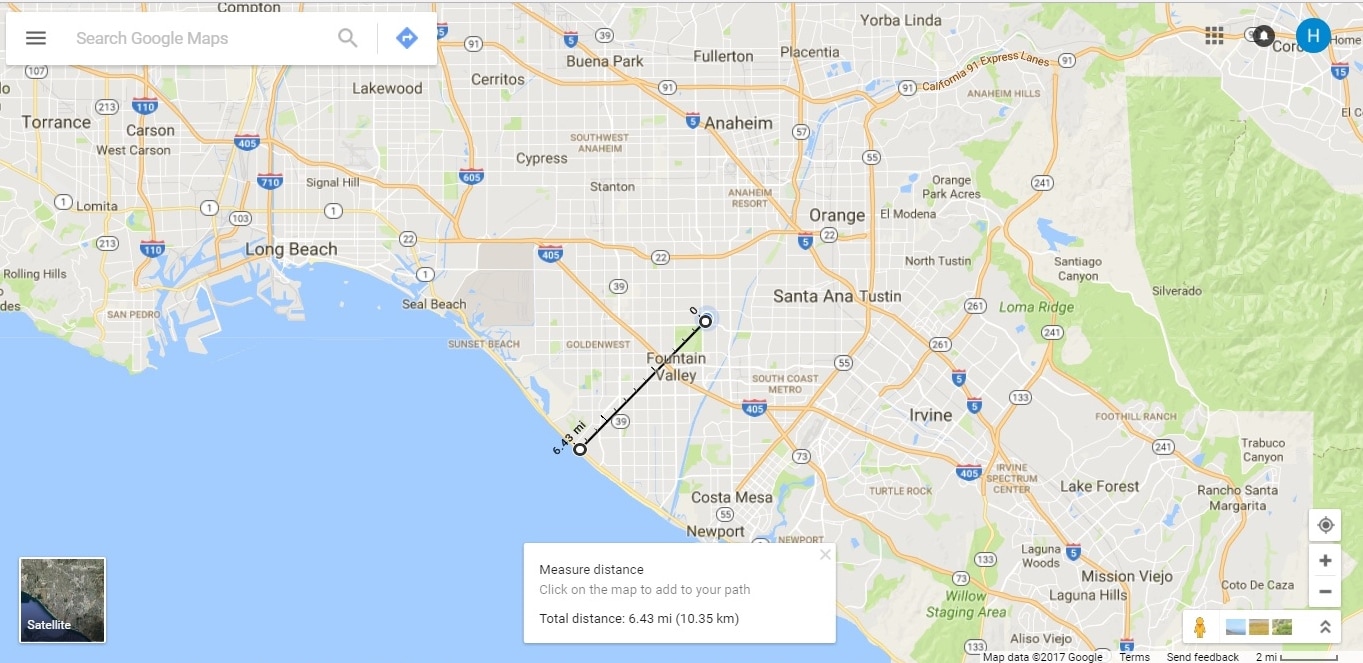
That considered, should a tsunami occur, it might be a good idea if all coastal residents (and evacuation routes, and cities, and tourists) were prepared, not just the cities with shoreline boundaries. In the event of a tsunami, vehiclists at the coast would hopefully head inland along the designated Evacuation Routes (Including Edinger Ave., Heil Ave., Warner Ave., Bushard St., and Brookhurst St. and possibly Ward St. for Huntington Beach; the map for Newport Beach does not list evacuation routes for the area within Newport Beach that borders the Santa Ana River/Huntington Beach, which is the area directly south of Riverview West Neighborhood). The Evacuation Routes along the coast are supposedly labeled with Tsunami Evacuation Routes signage; however, some of those routes lead into Riverview West Neighborhood, and Riverview West Neighborhood has no Tsunami Evacuation Route signage. Would it be conceivable for a traffic jam and gridlock to occur in the midst of panic? There are Tsunami Warning Sirens in the cities with shorelines; however, it is unknown if there are Tsunami Warning Sirens in nearby Santa Ana's Riverview West Neighborhood. Perhaps tsunami preparedness should be addressed for residents in Santa Ana as well as for its neighbors in the shoreline communities. When residents in Santa Ana's Riverview West Neighborhood are a 15-minute drive (as close as 6.43 miles) to the ocean, and within the State of California's designated tsunami inundation zone, all residents should be considered as coastal residents; all should be equally informed and prepared should a disaster strike. If all of the coastal cities were to work together in preparing for a tsunami, how much better prepared for successfully surviving the event everyone would be.
The cities of Huntington Beach and Newport Beach have lovely brochures on Tsunami safety; it would be nice if neighboring cities, including Santa Ana, were to have such brochures readily available and accessible to residents and visitors alike. However, it would be even better if all cities in the Orange County area were to adopt a unified projection of what the worst-case scenario tsunami could do to the region and create tsunami inundation maps based on that as opposed to presenting underestimating (or underdevastating), contradictory maps that leave the overall community divided in its approach to emergency planning.
The cities of Huntington Beach and Newport Beach have lovely brochures on Tsunami safety; it would be nice if neighboring cities, including Santa Ana, were to have such brochures readily available and accessible to residents and visitors alike. However, it would be even better if all cities in the Orange County area were to adopt a unified projection of what the worst-case scenario tsunami could do to the region and create tsunami inundation maps based on that as opposed to presenting underestimating (or underdevastating), contradictory maps that leave the overall community divided in its approach to emergency planning.
"'And of course, low-lying coastal areas will take the worst hits even from relatively low waves,'" points out Aggeliki Barberopoulou of the University of Southern California, who carried out the computer simulations. For instance, whereas in hilly San Francisco waves might move inland by just a couple of city blocks, in places such as Newport Beach (in Orange County), the inundation may reach a mile or more farther, making evacuation more difficult." (par. 7). "New Map Reveals Tsunami Risks in California." Davide Castelvecch, Davide.
WAYS TO PREPARE RIVERVIEW WEST NEIGHBORHOOD:
- Stay informed via social media: AlertOC, ReadyOC, Nixle, Pacific Disaster Center (PDC), American Red Cross (Orange County), Orange County Fire Authority, Orange County Emergency Management, California Office of Emergency Services, Riverview West Nextdoor.
- Find out if your home is in a vulnerable area by finding out the distance it is from the coast.
- If you live or are in a low-lying area – for instance near to the beach – identify the quickest way to get to high ground. A safe area would be at least 30m (or 100 feet) above sea level and 7+ miles inland. Teach and practice your evacuation plan with all family members.
- Ensure that all family members can recognize natural tsunami signs as timely, official Tsunami Warnings may not be possible.
- Discuss tsunamis with your family and friends. Everyone needs to know what to do in case all members are not together.
- Emergency supplies and equipment such as canned foods, medication, flashlights, battery-powered radios, clean water and First Aid kits should be readily available and working properly.
- Post Tsunami Evacuation Route signage on Euclid St., Newhope St., Harbor Blvd., Edinger Ave., McFadden Ave., 1st St., and 5th St.
- Install Voice Mass Notification Speakers as well as Tsunami Sirens for the areas of Riverview West designated as tsunami inundation zones for the State of California (from Euclid St. and Edinger Ave. to 6th St. and the Santa Ana River).
- Have Orange County Fire Authority Station #78 (at Newhope St. and 5th St. in Riverview West) test tsunami warning sirens at noon on the first Friday of each month.
- Tune into your AM/FM radio to 107.9 FM and turn your TV to a local LA-based station (KCAL, KTLA, etc.) to listen for emergency information when tsunami warning sirens sound at times not designated for testing.
- Hold Tsunami Evacuation Drills that include Voice Mass Notification Speakers and Tsunami Sirens
- Make swimming lessons available to all school-aged children in Riverview West Neighborhood (perhaps, included in the local schools Physical Education program annually).
- Community Education in schools and at public events
- Become CERT trained (for free!) through local fire departments such as Costa Mesa Fire Department (the Santa Ana Fire Dept. was sold to the OC Fire Authority, which does not offer the CERT program. Santa Ana's former fire dept. CERT program has been drastically lessened and is now offered through the City of Santa Ana. The CERT program may be more fully provided through surrounding cities' fire departments; however, residents of those cities may have priority registration over non-city residents. When completed through a city fire department, trainees receive certification that may aid in legal protection under Good Samaritan laws. For more information about the CERT program and its origins, please visit the Los Angeles Fire Department's CERT website.
- Modify your home and yards to better withstand flooding: 1) Elevate the first living space floor to be above flood level (minimum of 4 feet for Santa Ana...such as above a garage and open patio), 2) Plant sturdy trees around the perimeter of your yard to create a barrier to stop large debris from damaging your home, 3) Install adequately secure fencing (such as iron) around your property to prevent/minimize debris flow from damaging your home, 4) Grade your yards to drain away from your home (as well as away from your neighbors' homes), 5) Install rain gutters along your home's roof, 6) Create a bioswale/dry creekbed to draw water run-off from the rain gutters toward berms and/or a rain garden located away from your home, 7) Create berms to prevent run-off and direct excess water into sponge-like rain gardens, 8) Turn the city-owned median strip of grass/weeds between the sidewalk and the street into a bioswale that acts like a deep sponge to absorb excess water
- Get life vests and a boat!
RESOURCES:
CGS Tsunami Program
California Seismic Safety Commission
National Oceanic and Atmospheric Administration (NOAA) Center for Tsunami Research
"The Biggest Tsunami Recorded Was 1,720 Feet Tall and Chances Are Good It Will Happen Again."
"Tsunami Preparedness in Southern California, USA"
"Japan Tsunami Caught On Tape | BBC Natural Disasters & Weather Documentary 2016."
FEMA Flood Map Service Center | Welcome!
The Tsunami Zone
Cal OES My Hazards
Harbor Mixed-Use Corridor Plan
"Huntington Beach Holds Tsunami Evacuation Drill"
"How to Prepare for a Tsunami..."
California Department of Conservation, CGS Information Warehouse: Tsunami
HELPFUL INFORMATION FOR TSUNAMI-PRONE NEIGHBORHOODS SUCH AS RIVERVIEW WEST:
"Tsunami Preparedness," City of Huntington Beach.
The City of Huntington Beach has been certified by the National Weather Service as TsunamiReady. Download information on what Huntington Beach residents need to know to prepare for a tsunami and Download the City Tsunami Evacuation Map.
The word "tsunami" is Japanese and means 'harbor wave,' because of the devastating effects these waves have had on low-lying coastal communities. Tsunamis are often incorrectly referred to as tidal waves, but a tsunami is actually a series of waves that can travel at speeds averaging 450 (and up to 600) miles per hour in the open ocean. In the open ocean, tsunamis would not be felt by ships because the wavelength would be hundreds of miles long, with an amplitude of only a few feet. This would also make them unnoticeable from the air. As the waves approach the coast, their speed decreases and their amplitude increases. Unusual wave heights have been known to be over 100 feet high. However, waves that are 10 to 20 feet high can be very destructive and cause many deaths or injuries.
All eight fire stations in Huntington Beach have warning sirens that will be used in the event of a tsunami. They are tested at noon on the first Friday of each month. When you hear the siren activate at any other time, turn on your AM/FM radio to 107.9 FM and turn your TV to a local LA based station (KCAL, KTLA, etc.) to listen for emergency information.
Stay tuned to your AM/FM radio or television stations during a tsunami emergency. Bulletins issued through the Huntington Beach Emergency Management and Homeland Security Office and NOAA offices can help save your life!
For more information on tsunamis see:
"Tsunami Preparedness," City of Huntington Beach.
The City of Huntington Beach has been certified by the National Weather Service as TsunamiReady. Download information on what Huntington Beach residents need to know to prepare for a tsunami and Download the City Tsunami Evacuation Map.
The word "tsunami" is Japanese and means 'harbor wave,' because of the devastating effects these waves have had on low-lying coastal communities. Tsunamis are often incorrectly referred to as tidal waves, but a tsunami is actually a series of waves that can travel at speeds averaging 450 (and up to 600) miles per hour in the open ocean. In the open ocean, tsunamis would not be felt by ships because the wavelength would be hundreds of miles long, with an amplitude of only a few feet. This would also make them unnoticeable from the air. As the waves approach the coast, their speed decreases and their amplitude increases. Unusual wave heights have been known to be over 100 feet high. However, waves that are 10 to 20 feet high can be very destructive and cause many deaths or injuries.
- All earthquakes do not cause tsunamis, but many do. When you hear that an earthquake has occurred, stand by for a tsunami emergency message.
- An earthquake in your area is one of nature's tsunami warning signals. Do not stay in low-lying coastal areas after a strong earthquake has been felt.
- Tsunamis are sometimes preceded by a noticeable receding of sea level as the ocean retreats seaward exposing the seafloor. A roar like an oncoming train may sometimes be heard as the tsunami wave rushes toward the shore. These are also nature's tsunami warning signals.
- A tsunami is not a single wave, but a series of waves. Stay out of danger areas until an "all-clear" is issued by competent authority.
- A small tsunami at one point on the shore can be extremely large a few kilometers away. Don't let the modest size of one make you lose respect for all.
- All warnings to the public must be taken very seriously, even if some are for non-destructive events. The tsunami of May 1960 killed 61 people in Hilo, Hawaii because some thought it was just another false alarm.
- All tsunamis like hurricanes are potentially dangerous, even though they may not damage every coastline they strike.
- Never go down to the shore to watch for a tsunami. When you can see the wave you are too close to escape it. Never try to surf a tsunami; most tsunamis are like flash flood full of debris and they do not curl or break like surfing waves.
- Sooner or later, tsunamis visit every coastline in the Pacific and other oceans. If you live in any coastal area, be prepared and know nature's tsunami warning signs.
- During a tsunami emergency, your local civil defense, police, and other emergency organizations will try to save your life. Give them your fullest cooperation.
All eight fire stations in Huntington Beach have warning sirens that will be used in the event of a tsunami. They are tested at noon on the first Friday of each month. When you hear the siren activate at any other time, turn on your AM/FM radio to 107.9 FM and turn your TV to a local LA based station (KCAL, KTLA, etc.) to listen for emergency information.
Stay tuned to your AM/FM radio or television stations during a tsunami emergency. Bulletins issued through the Huntington Beach Emergency Management and Homeland Security Office and NOAA offices can help save your life!
For more information on tsunamis see:
